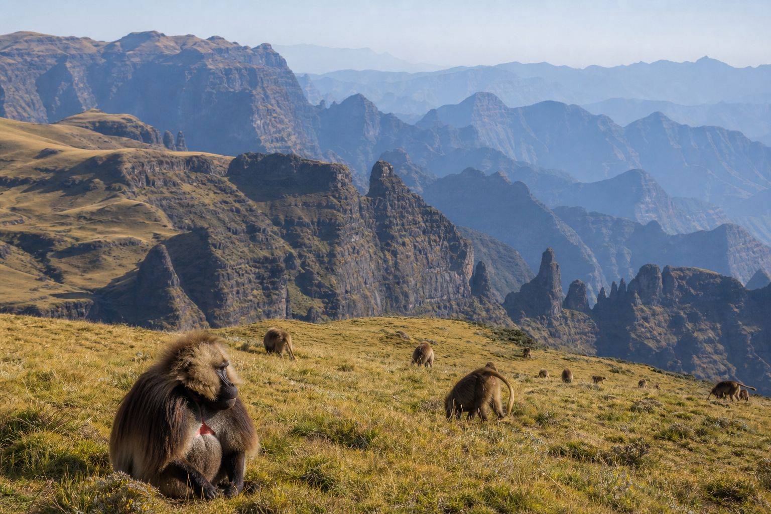
 The Simien landscape combines high plateaus, deep valleys, sharp cliffs, and habitat for species found only in Ethiopia.
The most surprising part of the Simien Mountains is often the edge. A broad highland plateau can look gentle until it ends at a cliff and the land drops into layered valleys, pinnacles, and distant ridges.
UNESCO describes precipices dropping about 1,500 metres in parts of the park. The same landscape supports Walia ibex, geladas, Ethiopian wolves, raptors, and highland plants adapted to altitude.
This is not a viewpoint reached casually from a city pavement. Even a short visit requires current access information, park arrangements, weather preparation, and respect for the people and wildlife living in and around the protected area.
Current safety note
Simien National Park is in Amhara Regional State. As of 6 August 2026, both the United Kingdom and the United States currently say do not go there. The UK’s live advice recommends against all travel to the whole of Amhara because of armed conflict, roadblocks, detention risk, crime, and rapidly changing conditions. The US advisory, dated 1 April 2026, rates Ethiopia overall Level 3, Reconsider Travel, and separately tells the public, not only government staff, not to travel to Amhara among other regions.
Do not assume that a tour advertised online is safe, insured, or currently operating with official approval. If government advice says not to travel, postpone the trek. Do not assume every route, camp, or trail named in this guide is currently open. Ask the park authority which parts of the park are open, and confirm water sources, fees, mandatory guide or scout rules, closures, and evacuation arrangements at the time, since none of that is confirmed here.
Why the Simiens are a World Heritage property
Simien National Park joined the World Heritage List in 1978. Its value combines landscape and biodiversity. Long erosion has cut the Ethiopian plateau into deep valleys, sharp cliffs, and isolated peaks.
The park is especially important for threatened and endemic species. The Walia ibex is a wild goat found only in Ethiopia. Geladas are grazing primates often seen in groups on open highland grass. Ethiopian wolves are rarer and should never be promised as a guaranteed sighting.
The park also includes settlements, cultivated land, livestock routes, and communities whose lives cannot be separated from conservation. A trek should not present the landscape as empty wilderness.
Choose the right kind of visit
Not every visitor needs a long expedition.
A short visit can include an authorized vehicle route, a viewpoint, and a modest walk near an established camp or trail. This suits travellers with limited time who still prepare for altitude and uneven ground.
A two or three day trek allows sunrise and evening light, several escarpment sections, and a better chance to observe geladas without rushing. It also introduces camping conditions, repeated climbs, and colder nights.
A longer trek toward remote camps or high peaks requires strong fitness, acclimatization, reliable logistics, and recent route information. It should not be attempted because an old itinerary labels it moderate. Confirm every named route, camp, water source, road, and evacuation option with the park office and your authorized operator before you commit to it.
A sensible first trekking plan
When access is safe, a first trek should begin with a moderate day rather than the longest available route. Use the first afternoon for registration, guide briefing, equipment check, and a short acclimatization walk.
The next day can follow an established escarpment route with frequent stops. A third day may add another viewpoint or wildlife area before returning to the park entrance.
Keep route choices flexible. Fog, rain, fire, road damage, wildlife management, or security instructions can close an area. Your guide and park staff should be willing to change the plan.
Do not schedule a tight flight or long road transfer immediately after the trek. Delays are part of remote travel.
Permits, guides, scouts, and operators
Park entry, registered guides, scouts or rangers, camping, vehicles, cooks, and pack animals may involve separate arrangements. Requirements have changed over time. Confirm the current system directly with the park authority: ask what is mandatory, what is optional, who receives each payment, and whether an official receipt is issued.
Choose an operator that provides a written route, realistic walking times, food plan, water treatment method, staff names, emergency communication, first aid capacity, and an evacuation plan.
Ask how porters, cooks, animal handlers, and guides are paid and equipped. A low package price can shift cost and risk onto local staff.
Altitude is the main physical issue
Much of the park lies at high elevation. Headache, poor sleep, nausea, unusual fatigue, dizziness, and shortness of breath can signal altitude illness.
Fitness does not prevent altitude sickness. Ascend gradually where possible, drink normally, avoid heavy alcohol, eat enough, and tell your guide about symptoms early.
Do not keep climbing to protect an itinerary. Worsening symptoms require descent and medical assessment. Severe confusion, inability to walk steadily, or breathing difficulty at rest are emergencies.
The CDC’s Yellow Book guidance for travellers gives a concrete rule worth following above 3,000 metres, which much of the Simien route reaches or exceeds: increase your sleeping elevation by no more than about 500 metres per night, and add a full acclimatization day for every additional 1,000 metres you plan to gain. A person whose symptoms are getting worse, not staying the same, should not keep ascending. Confusion, loss of coordination, or breathlessness while resting are emergency signs that call for immediate descent and medical help, not a shorter break.
Readers with heart, lung, blood, or pregnancy related concerns should seek medical advice before planning. Travel insurance must cover trekking at the intended altitude and evacuation from a remote area, so confirm the highest sleeping elevation and route altitude with your operator before you buy a policy.
Weather and seasons
Highland weather changes quickly. A clear morning can become foggy, wet, windy, and cold. Strong sun at altitude can burn skin even when the air feels cool.
Rain affects road access, trail grip, stream levels, and camping comfort. Dry periods can bring dust and strong temperature changes between day and night.
There is no permanent best month without current conditions. Ask the park authority and recent local operators about rainfall, road condition, fire, water, and trail closures for the dates you have in mind.
Carry rain protection even when the forecast looks dry. Keep warm layers accessible rather than buried in a packed bag.
What to pack
For a day walk:
- Broken in walking shoes or boots with reliable grip
- Rain shell
- Warm layer
- Sun hat, sunscreen, and sunglasses
- Water and treatment backup
- Food for the planned day plus delay
- Personal medicine
- Small first aid kit
- Charged phone and power bank
- Secure copy of identification
For camping, add a sleeping bag rated for expected night temperatures, insulating mat, headlamp, spare batteries, dry bags, warm hat, gloves, and clean socks. Confirm what the operator genuinely supplies, and inspect tents, sleeping bags, cooking equipment, and communication devices before departure rather than trusting the brochure description.
Water, food, and hygiene
Do not assume a clear mountain stream is safe to drink. Use water provided and treated by a reliable operator, or carry an effective treatment method you know how to use.
Eat enough carbohydrate and salt during long walking days. Tell the cook about allergies in clear language before the trek. Fasting menus may be plant based, but that does not automatically make them safe for every allergy.
Carry out personal waste. Follow the camp system for toilets and rubbish. Soap, sunscreen, and food scraps should not enter streams.
Wildlife etiquette
Geladas may allow people to approach more closely than expected. That does not make them tame.
Keep the distance set by park staff. Do not surround a group, block its route, imitate calls, offer food, or place a person between a mother and young animal. Sit quietly and let the animals move.
Walia ibex often occupy steep terrain. Do not approach cliff edges for a closer photograph. Ethiopian wolves are rare. Never ask a driver or guide to chase one across habitat.
Use a zoom lens from a stable position. Avoid playback calls for birds. Report injured wildlife to park staff rather than attempting a rescue.
Cliff and trail safety
The landscape creates strong photographs and real fall risk. Rock edges can crumble. Grass can hide holes. Fog can remove depth perception.
Stay on the guide’s side of a marked limit. Do not jump across gaps, sit with legs over an edge, or walk backward while filming. Keep children within reach.
Give pack animals room on narrow trails and stand on the safer inner side when they pass. Never touch an animal or adjust its load without the handler’s permission.
Lightning is a concern on exposed high ground. Follow the guide’s decision to turn back or leave a ridge.
Communities and cultural respect
People farm, herd animals, attend school, trade, and travel through the wider landscape. Ask before photographing anyone, especially children.
Do not hand out sweets, pens, or money randomly. If you want to support a school or community project, ask a trusted local organization what is useful and accountable.
Buy food and crafts at agreed prices. Do not enter a home, field, church, or sacred place without invitation. A landscape photograph should not erase ownership and daily work.
Getting there when travel is possible
Debark is the established gateway town for park arrangements, while Gondar often serves as a larger transport base with its own airport. A catalogue published by the Ethiopian Wildlife Conservation Authority puts the distance from Gondar airport to Debark at roughly 105 kilometres, about two hours under ordinary road conditions. Treat that figure as a description of normal conditions, not a current guarantee, since checkpoints, road damage, or security instructions can add significant time or close the route entirely.
Ministry material names Buyit Ras, Sankaber, Gich, and Chennek as established locations within the park, but their appearance in official material does not mean every route or camp among them is currently open. Roads, flights, checkpoints, and park registration can all change.
For the historical destinations often planned beside the park, see Best Historical Places to Visit in Ethiopia.
Confirm every transport leg close to departure. Avoid driving after dark, carry water, food, and communication backup, and leave the itinerary with a reliable person outside the trekking group.
Do not rely on a map estimate for mountain travel time. Road surface, rain, stops, and official checks can add hours.
Common mistakes
- Underestimating altitude because the trail looks gentle
- Booking a long trek without a moderate first day
- Treating geladas as tame animals
- Standing at an unstable cliff edge for a photograph
- Assuming the operator supplies warm and waterproof equipment
- Drinking untreated stream water
- Publishing old permit and guide rules
- Paying a very low price without asking how staff are treated
- Driving remote roads after dark
- Assuming park advertising overrides a regional travel warning
A responsible decision
The Simiens reward slow movement. A good day is not measured only by distance. It may be the hour spent watching geladas graze, the decision to turn back before fog covers a ridge, or the conversation that explains how a nearby community uses the land.
When official access and safety support travel again, choose a route below your maximum ability, allow time to acclimatize, hire authorized local staff, and carry proper weather protection. Until then, keep the plan flexible and the booking refundable. The landscape will still be there when the journey can be made responsibly.